Rainbow Falls Trail Smoky Mountains: Insider Tips So You Actually Enjoy the Trek
You know that moment on a hike when your legs are screaming, your lungs are negotiating with you, and you start questioning every life choice that led you here?
That’s exactly what you’ll feel somewhere around mile two of the Rainbow Falls Trail—but don’t worry, the payoff is worth every ounce of sweat.
The Rainbow Falls Trail Smoky Mountains isn’t just another walk in the woods; it’s a full-on experience with switchbacks that will test your stamina and a waterfall that steals the spotlight at the end.
We’re talking about the tallest single-drop cascade in the Smokies, complete with misty rainbows if you time it right.
Follow along because this is the insider’s guide that’ll make the difference between misery and magic on the Rainbow Falls Trail Smoky Mountains!
So, How Far Is It Really (a.k.a. Will You Survive?)
Where the Hike Begins (and Your Patience Gets Tested)
Your journey starts at the Rainbow Falls Trailhead, which you’ll find just a short drive from downtown Gatlinburg.
To get there, you’ll head up Cherokee Orchard Road, a winding route that feels charmingly rustic until you realize half the state of Tennessee is looking for the same parking lot.
The lot itself is limited and fills up faster than a brunch spot with bottomless mimosas, so arriving early isn’t just a tip—it’s survival.
If you miss the main area, don’t panic; there’s an overflow option a bit further down the loop, but it does add extra steps to your already ambitious day.
Spoiler: It’s Not a Leisurely Stroll
The Falls Trail is a steady climb that tricks you into thinking the first stretch will be easy, only to unleash a parade of switchbacks.
Clocking in at 5.4 miles roundtrip, it balances out as an uphill grind that feels longer thanks to the terrain.
Some hikers swear it’s about 1.7 miles before you start seriously questioning your cardio, while the big reveal comes at roughly 2.7 miles when the waterfall finally shows itself.
With over 1,600 feet of elevation gain, this isn’t just a casual outing—it’s a workout disguised as sightseeing.
How Long You’ll Be Away From Civilization
Plan on setting aside three to five hours for this trek, depending on your pace and how long you spend gawking at the falls.
The climb slows most hikers down, so don’t assume you’ll breeze through just because you’ve tackled other trails before.
Breaks are practically mandatory, whether for catching your breath, snapping photos, or bribing your legs to keep moving.
By the time you’re back at your car, you’ll feel like you’ve been off-grid for half a day—even though Gatlinburg and its pancake houses are right around the corner.
The Play-by-Play Before You Lace Up Those Boots
The Falls: Why Everyone’s Really Here
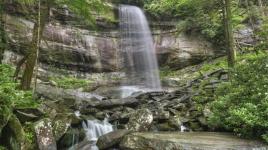
At the heart of the hike is Rainbow Falls, the show-stealing cascade that makes every sweaty step worth it.
As the highest single drop waterfall in the park, it thunders 80 feet down into the creek below and delivers a dramatic mist that feels like nature’s air conditioning.
On sunny afternoons, the spray often forms a rainbow, and visitors can’t resist writing glowing Rainbow Falls reviews about the spectacle.
Just don’t climb the slippery rocks—this beauty is best admired from a safe spot with your camera at the ready.
The Hike: Your Love-Hate Relationship With Uphill Trails
The trail winds along the creek before kicking into a relentless climb that cements its reputation as both rewarding and exhausting.
Many Rainbow Falls Gatlinburg reviews mention the tricky terrain and the way the switchbacks keep testing your patience mile after mile.
It’s a rocky path with old-growth forest, fire-scarred areas, and plenty of shade, reminding you this is more than just a path to an 80-foot high waterfall—it’s an experience.
Think of it as cardio with bragging rights, and the mountain makes sure you earn every single one.
Beyond the Falls: For Those Who Think 5 Miles Isn’t Enough
If you’re still buzzing with energy after seeing the waterfall in the Smokies, the adventure doesn’t stop there.
Keep climbing another four miles and you’ll reach the summit of Mt LeConte, one of the park’s most beloved destinations with sweeping views and lodge accommodations.
Along the way, the trail offers quiet forest sections, wildlife spotting opportunities, and a few great picnic sites that tempt you to stretch out and savor the moment.
It’s a longer, tougher journey, but the sense of accomplishment is as epic as the scenery.
Why Timing Is Everything (Especially for Instagram)
Spring Into Wildflowers and Cool Breezes
Spring on the trail feels like hitting refresh after a long winter, with wildflowers popping up along the creek and cool breezes carrying that earthy mountain smell.
The climb still demands effort, but the scenery makes it easier to forget how steep the switchbacks really are.
Crowds are lighter compared to summer, giving you more room to enjoy the blooming forest in peace. It’s the season when the Smokies roll out their softer, pastel palette before things really heat up.
Summer Heat Meets Mountain Mist
Summer is the busiest season on the trail, but also the most photogenic if you time it right.
During extended cold periods, an impressive ice formation builds around the Rainbow Falls, living up to its name in the best way.
Temperatures can soar, so hitting the trail early helps you avoid both the crowds and the midday humidity.
Just remember, afternoon thunderstorms aren’t rare, so pack a rain jacket alongside your camera.
Don’t Fall Behind—This Is Peak Leaf-Peeping Season
Fall is pure magic in the Smokies, with golden light hitting the trees and every switchback framed in fiery reds and oranges.
Cooler air makes the climb easier, and hikers linger at the falls longer just to soak in the crisp weather.
This is prime Instagram time, so expect plenty of company on the trail and parking lot competition that rivals summer. Still, the foliage backdrop makes every step feel cinematic.
Winter Is Coming… With Icy Trails and Epic Views
Winter cuts the crowds way down and rewards hikers who don’t mind bundling up. During extended cold periods, an impressive ice formation builds, transforming the waterfall into a frozen sculpture you’ll never forget.
The trail can be slippery with ice patches, so traction gear and layers are a must. It’s a quieter, moodier version of Rainbow Falls that feels like the Smokies are letting you in on a secret.

How to Not Regret This Life Choice by Mile Two
Before you set foot on the trail, a little prep goes a long way in making sure your hike is more “epic adventure” than “why did I do this to myself?”
With the right gear, timing, and insider tricks, you’ll transform a strenuous climb into one of those unforgettable adventures that you’ll brag about long after your calves stop burning.
Good shoes aren’t optional here—Great Smoky Mountains National Park trails like this one demand sturdy, broken-in footwear that can handle rocky switchbacks and uneven footing.
Blisters or wobbly ankles are the fastest way to turn a bucket-list hike into misery.
Of course, no pair of boots can save you from dehydration, which is why water is your real best friend on the climb.
The uphill grind is no joke, and having plenty to drink—especially in summer—makes the difference between powering through and calling it quits.
Even with hydration sorted, the weather can still surprise you, so layering is the smartest play.
The air near the waterfall runs cooler, and sudden shifts in temperature are common once you’re deep into the forest.
Then there’s the parking situation, which deserves its own strategy.
Arriving at the trailhead early is key to snagging a spot, and don’t forget: a parking pass is required to start reaching Rainbow Falls without stress.
Finally, while you can’t swim under the falls, there’s still a way to make the experience feel up close and personal.
A short side path leads to a wooden platform with a perfect vantage point—arguably the best place to appreciate the roar of the cascade without getting drenched.
What’s Next After Conquering the Falls?
So you’ve sweated, climbed, and triumphed your way up the Rainbow Falls Trail, and now you’re wondering—what else is waiting in the Smokies?
The answer: plenty, because finishing the Rainbow Falls Trail Smoky Mountains is just the beginning of what Gatlinburg has to offer.
To really make the most of your trip, it helps to plan ahead with vacation packages through Tripster. Score deals on Gatlinburg attractions, shows, and hotels without stressing over the details or blowing your budget.
Suddenly, that waterfall adventure turns into a full-blown getaway packed with mountain charm and memory-making moments.
So go ahead—book smart, hike hard, and let the Smokies give you the trip you’ll never forget!
What Are The Rainbow Falls Trail FAQs?
How difficult is the hike?
It’s considered moderate to strenuous due to the elevation gain of more than 1,600 feet and the rocky terrain. Beginners can complete it with breaks, but sturdy shoes and endurance are essential.
How long does it take to hike to Rainbow Falls?
Most hikers finish in 3 to 5 hours depending on pace and time spent at the falls. Faster hikers may complete it quicker, but the climb can slow you down.
Where is the Rainbow Falls Trailhead located?
The trailhead sits off Cherokee Orchard Road, just outside downtown Gatlinburg. From traffic light #8, follow signs toward the one-way Cherokee Orchard Loop to reach the parking lot.
When is the best time to hike the trail?
Late spring through early fall offers great conditions, with blooming wildflowers in spring and colorful foliage in fall. Summer brings crowds, while winter offers fewer hikers but icy conditions.
Can you see rainbows at Rainbow Falls?
Yes, on sunny afternoons, the mist from the 80-foot cascade often creates a rainbow effect. Your best chance to see it is midday when the sun is high.
Is swimming allowed at Rainbow Falls?
No, swimming is prohibited for safety reasons due to slippery rocks and strong currents. However, you can get close views from a wooden platform just past the main overlook.
Can I continue hiking beyond Rainbow Falls?
Yes, the trail continues about 4 more miles to the summit of Mount LeConte. This extension is much steeper and best for experienced hikers.
Do I need a parking pass for the trailhead?
Yes, Great Smoky Mountains National Park requires a parking tag for vehicles parked more than 15 minutes. Tags can be purchased in advance or at kiosks in the park.
Are pets allowed on Rainbow Falls Trail?
No, pets are not permitted on the trail to protect wildlife and maintain safety. Dogs are allowed only on designated pet-friendly trails within the park.